Visar inlägg med etikett Oregon. Visa alla inlägg

25 augusti 2018

Smith Rock, Oregon, 20JUL2018

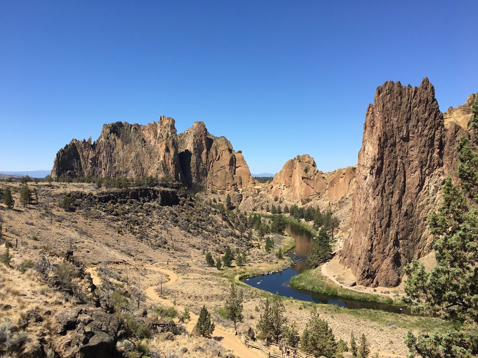
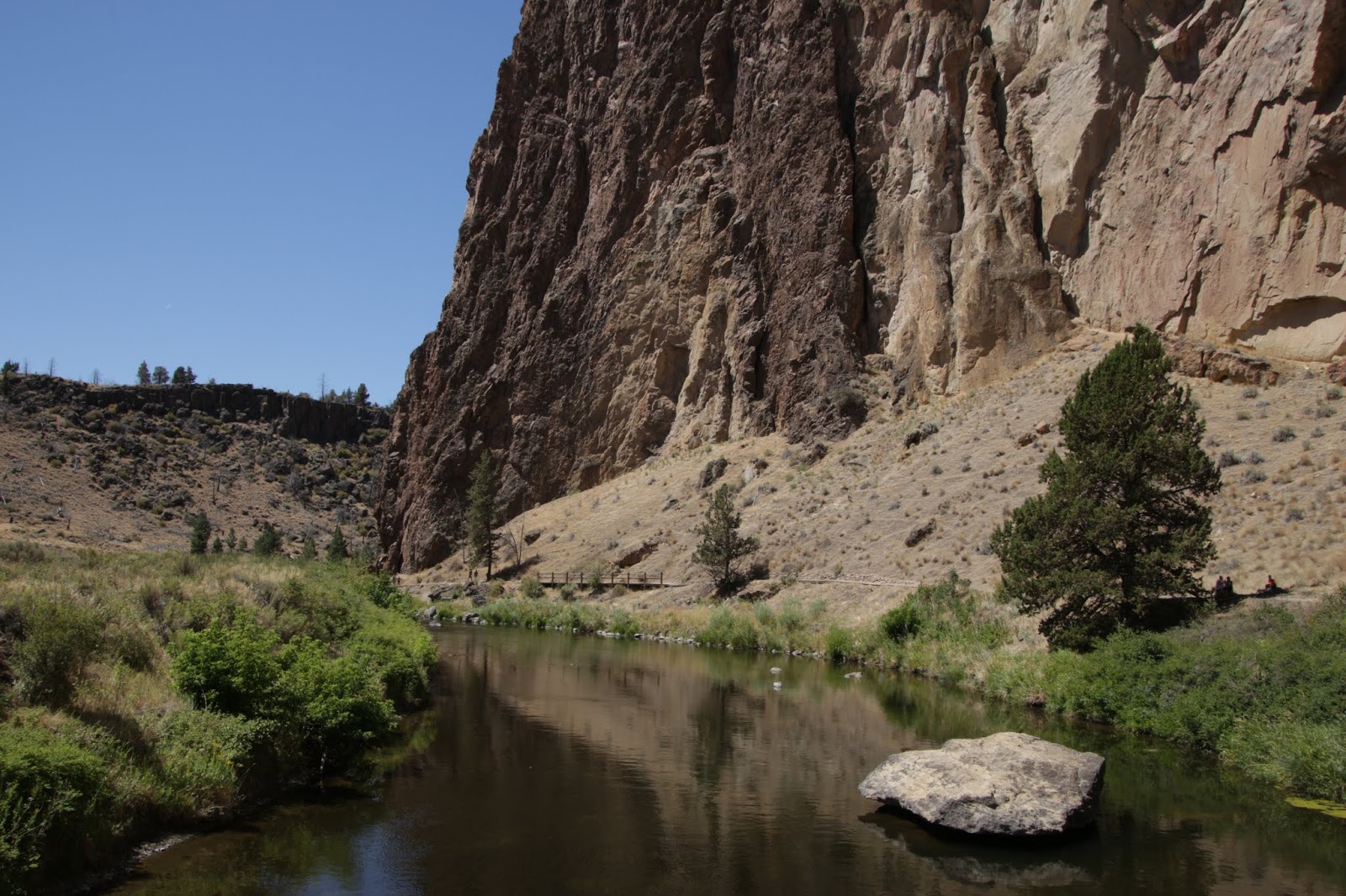
Smith Rock är ett litet bergmassiv i centrala Oregon, nära staden Terrebonne. Genom massivet rinner den lilla floden Crooked River. Området är känt framförallt bland bergsklättrare. Där finns flera vandringsleder av varierande svårighetsgrad. Vi gick först längs River Trail, en av de enklaste lederna, för att sedan fortsätta in på Misery Ridge Trail, som är den svåraste. Den går upp på baksidan av berget och kommer ner igen på samma sida som parkeringen. Fantastiskt vacker utsikt både på vägen upp och uppe på toppen, men även nere längs Crooked River. Det tog oss ungefär tre timmar att gå hela vandringsleden från parkeringen och tillbaka igen, ungefär sju kilometer. Den värsta biten var faktiskt avslutningen, backen tillbaka upp från floden till parkeringen. Vi hade två liter vatten med oss var, och de gick åt. Det var fint väder och 35 grader C.


"The geology of Smith Rocks is volcanic. It is made up of layers of recent basalt flows overlaying older Clarno ash and tuff formations. Approximately 30 million years ago, a large caldera was formed when overlying rock collapsed into an underground lava chamber. This created a huge amount of rock and ash debris that filled the caldera. That material solidified into rock, becoming Smith Rock tuff. Rhyolite flows intruded along faults in the Smith Rock Tuff. A half million years ago, basalt lava flows from nearby volcanoes covered the older tuff.

More recently, the Crooked River cut its way through the layers of rock to create today's geographic features. Smith Rock itself is a 3,200-foot (980 m)-high ridge (above sea level) with a sheer cliff-face overlooking a bend in the Crooked River (elev. 2600 ft), making the cliffs about 600 feet high."

"Monkey Face Area
The Monkey Face area has many routes, but is known for the iconic rock spire known as "Monkey Face," a distinctly primate looking face when viewed from certain angles. This iconic tower is 350 feet tall and boasts many routes. One of the more famous routes, Just Do It (5.14c), is still a testpiece for climbers to prove their prowess."

https://en.wikipedia.org/wiki/Smith_Rock_State_Park


Monkey Face


Vid basen av Monkey Face

Nästan i jämnhöjd med Monkey Face. Ser inte riktigt ut som ett ansikte från den här vinkeln.
Stigen upp till toppen


Rätt brant grusstig i zick-zack upp mot toppen.

Mount Jefferson, 3 200 m.ö.h.

Nära toppen.


Dags att gå ner på andra sidan.


Där nere vid bron började River Trail. Vi gick åt höger i bild. 


Newberrykratern, Oregon, 19JUL2018


Newberrykratern, innefattande bland annat Paulina Peak, Lava Flow, Paulina Lake, East Lake och Paulina Falls.


"Newberry Volcano (also known as Newberry Caldera) is a large active shield-shaped stratovolcano located 35 miles (56 km) east of the major crest of the Cascade Range and about 20 miles (32 km) south of Bend, Oregon, within the Newberry National Volcanic Monument."

"Newberry Volcano possesses a large caldera 4 by 5 miles (6.4 km × 8.0 km) in diameter, called the Newberry Caldera. Within the caldera there are two lakes (Paulina Lake and East Lake). The volcano and its vicinity feature many pyroclastic cones, lava flows, and lava domes; it has more than 400 vents, the most of any volcano in the contiguous United States."

"Eruptive activity began about 600,000 years ago, and has continued into the Holocene, its last eruption taking place 1,300 years ago."

"Still considered an active volcano, it could erupt and produce lava flows, pyroclastic flows, lahars (volcanically induced mudslides, landslides, and debris flows), ashfall, earthquakes, avalanches, and floods. To monitor this threat, the volcano and its surroundings are closely monitored with sensors by the United States Geological Survey."

" Multiple eruptions created the caldera, but the main caldera-forming event occurred around 75,000 years ago from a major explosive eruption. It formed the crater lakes and Paulina Peak, which is the highest point on the volcano, at 7,989 feet (2,435 m)."

" Newberry Volcano has also produced a number of Plinian eruptions similar to the eruption of Vesuvius that destroyed Pompeii, rising 20 miles (32 km) or more into the stratosphere. The last of these eruptions covered tens of thousands of square miles with ash, extending to the San Francisco Bay Area in California, nearly 500 miles (800 km) to the southwest."

"1,300 years ago, the volcano underwent its most recent eruptions, producing the Big Obsidian flow. A silicic deposit, it is made up of rhyolite and features a number of lava blocks."

"Though Newberry Volcano is currently quiet, the United States Geological Survey considers it an active volcano with a "very high" threat level. Hot springs within the caldera remain active, and small earthquakes have occurred within recent local history. Any future eruptions would likely show similar characteristics to eruptions from the past 15,000 years, ranging from effusive production of lava flows to explosive eruptions ejecting pumice and ash. Lava flows from Newberry Volcano of comparable size to its late Pleistocene eruptions would bury settlements throughout the Central Oregon region."

"The trail to the volcano's summit at Paulina Peak lasts 15.5 miles (24.9 km) from Highway 97, with an easy paved road to the caldera and four rest stops, though it grows steep and twisty near the end. The winding trail near the end is made of gravel, and lasts for 3 miles (4.8 km), offering views of Mount Hood, Mount McLoughlin, and the Three Sisters volcanoes."

https://en.wikipedia.org/wiki/Newberry_Volcano

Paulina Peak
Höjd över havet: 2 434 meter
Höjd över närliggande omgivning: 980 meter

https://en.wikipedia.org/wiki/Paulina_Peak

På väg upp till Paulina Peak.


Utsikt från Paulina Peak.


Det stelnade lavaflödet sett uppifrån Paulina Peak.


Lavaflödets slut vid skogskanten.


Obsidian.

Promenadstigen inne i lavaflödet.


East Lake:


Paulina Falls: